
Jbel Toubkal ascent: 4,167 m from Imlil via the Toubkal refuges in two or three days
Jbel Toubkal, in Morocco's High Atlas, is 4,167 m high, and the usual way up starts in the village of Imlil, about 65 km by road from Marrakech. The path climbs the Ait Mizane valley past the terraces of Aremd and the shrine of Sidi Chamharouch to the Toubkal refuges at 3,207 m. From there it goes up scree and boulders to the summit. Most people take 2–3 days. In summer it is a hard walk with no climbing; from about December to March the route is under snow, and crampons and an ice axe are needed. A licensed local guide is required.

- High point
- 4,167 m · Jbel Toubkal
- Duration
- 2–3 days
- Best months
- Jun–Oct
- Difficulty
- Hard, non-technical
- Guide
- Required by park rules
For guidance only. Check details with your operator and the official sources listed at the end before you book.
Where to book and compare Jbel Toubkal ascent trips
Booking sites · affiliate linksEach site lists trips from several operators. Compare dates, group sizes, what is included and reviews there; we don't rank operators.
We earn a commission if you book through these links, at no extra cost to you. Prices and availability are on each site.
On this page
Which route should you choose?
Almost everyone climbs Toubkal by the same path. It leaves Imlil (1,740 m) and climbs the valley to Aremd (sources give 1,900 m or 1,950 m). It then passes the shrine of Sidi Chamharouch (2,350 m) to the two refuges at 3,207 m. On summit day it climbs the South Cwm (Ikhibi Sud) to the col of Tizi n'Toubkal (3,940 m) and the summit ridge. The routes below differ mainly in how many nights you spend at the refuge and in the season. The North Cwm (Ikhibi Nord) is a quieter summit line, about 1,000 m of climbing in 3 to 4 hours, often used as a descent variation with your guide.
One GPS route gives about 27 km and 2,250 m of climbing from Aremd to the summit and back; from the refuge to the summit and back is about 8.3 km. If you want more than the summit, the longer Toubkal circuit loops around the massif over several days and has its own page.
| Route | Days | Scenery | Crowds | Acclimatisation |
|---|---|---|---|---|
| Classic two days (Imlil, refuge, summit, Imlil)Up to the refuge on day 1; on day 2 the summit and the whole way down to Imlil, about 960 m up and 2,400 m down, usually 8 to 10 hours. You sleep at 3,207 m and reach 4,167 m the next morning, with little time to adjust. This is the most common plan. | 2 | Very good | High | Weaker |
| Three days, two nights at the refuge itinerary belowThe same path with one more night at the refuge. Either spend a day acclimatising before the summit, or climb and return to the refuge, then walk down to Imlil on day 3. Some people sleep in Imlil or Aremd first instead. | 3 | Very good | High | Good |
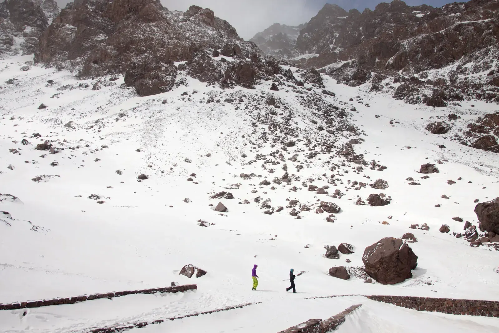
| Winter ascent with crampons and ice axeThe same line under snow, usually from December to March, sometimes in November and April. Crampons and an ice axe are needed, a rope is often used on the summit ridge, and one winter report gives about −10 °C outside the refuge at night. This is mountaineering, not trekking. | 2–3 | Excellent | Medium | Good |
| Western approach via Tizi MzikA less used way in. Day 1 goes from Imlil over Tizi Mzik (2,480 m) to the Azzaden valley and Azib Tamsoult, about 5 hours. Day 2 crosses Tizi Aguelzim to the Toubkal refuge, about 7 hours. Day 3 is the summit and the descent via Sidi Chamharouch. Better acclimatisation and far fewer people until the refuge. | 3 | Excellent | Low | Very good |
3-day Three days, two nights at the refuge itinerary at a glance
The itinerary below is the three-day plan with two nights at the refuge. It gives a shorter summit day and a little more time at altitude than the two-day climb. Day 1 climbs about 1,450 m to 1,500 m. The path goes through Aremd, across the floodplain and up to the shrine and tea stalls at Sidi Chamharouch, then on to the refuges. Sources give anything from about 3.5 to 7 hours; one timed party took 2 hours to Sidi Chamharouch and 2.5 hours more to the refuge.
Day 2 starts before dawn, typically between 4 and 6 am. The path climbs about 960 m over scree and boulders, marked with painted stones, to Tizi n'Toubkal and along the ridge to the metal summit pyramid. Allow about 2.5 to 3 hours up, then about 2 hours back to the refuge. Day 3 is the walk down to Imlil, about 5 to 6 hours on one source and about 3.5 hours for a fast timed party. Some groups use day 2 to acclimatise and climb on day 3 instead; on the two-day plan, the summit and the descent to Imlil are done on the same day.
- Day 1 Imlil Toubkal refuges (Refuge du Toubkal / Les Mouflons) via Sidi Chamharouch 2,350 mnight at 3,207 m
- Day 2 Jbel Toubkal summit Toubkal refuges summit 4,167 mnight at 3,207 m
- Day 3 Toubkal refuges Imlil night at 1,740 m
What it really costs
Package prices depend on group size, the number of nights and what is included, so compare them on the booking sites. The figures below, as of November 2026, are approximate and none is official; they help you check what a package covers if you arrange the guide yourself in Imlil. You may take at most 2,000 MAD in banknotes out of Morocco, and it is wise to take out cash in Marrakech before going up to the mountains.
Insurance that covers Jbel Toubkal ascent
Choose a policy that covers trekking and mountaineering to 4,167 m, including mountain rescue and helicopter evacuation. If you go between December and March, check it covers crampons and an ice axe. Rescue in the Moroccan mountains is carried out by the Gendarmerie, the Civil Protection and the army; when three people died in an avalanche in the Toubkal area in January 2026, the recovery involved all three.
Emergency numbers: 15 for ambulance and fire, 19 for police in towns, 177 for the Gendarmerie Royale in the countryside and mountains. The US State Department rates Morocco Level 2, exercise increased caution (reported current in September 2026); the UK government's Morocco safety page has a section on hiking. Read both before you book.
Staying connected in Morocco
An eSIM installed before you fly works in Morocco, and tourist SIM stands are found at airports. Maroc Telecom is reported as the strongest network in rural areas. Imlil has good 4G, but the signal drops on the way up and there is none at the Toubkal refuge. Tell someone your plan before you leave Imlil, download offline maps, and carry a power bank.
Getting there and where to stay
Fly into Marrakech (RAK), the gateway for Toubkal. Imlil is about 65 km south of Marrakech, under two hours by road via Asni. If there is no flight to Marrakech from your city, fly to Casablanca and connect there, or check for seasonal nonstops to Marrakech.
Getting there by air
Marrakech to Imlil
Gear: rent or buy
In summer nothing technical is needed, but the summit day is long, on loose scree, and above 4,000 m. Nights at the refuge are just above freezing even in summer, and early mornings above about 3,600 m can be below freezing. In winter, usually December to March and sometimes into April, the route is under snow and ice and becomes a mountaineering ascent. Crampons, an ice axe and winter boots are essential. Avalanches do occur: three people, a guide from Imlil and two Moroccan visitors, died in one in January 2026. Most winter accidents happen on the frozen south-southwest face.
- Broken-in boots with ankle support for scree and bouldersBuy
- Warm jacket, hat and gloves for the pre-dawn start and the summit windRent or buy
- Headlamp for the start, usually between 4 and 6 amBuy
- Trekking poles for the long, slippery descentRent or buy
- Crampons and ice axe from about December to March (sometimes November and April); ask your guide what fits your bootsRent
- Sleeping bag; ask your operator whether you need your own at the refugeRent or buy
- Water bottles plus purification tablets or a filterBuy
- Sun hat, sunglasses and high-factor sunscreenBuy
- Passport, needed at the police posts on the approachBuy
Add a few days in Morocco
Toubkal is close enough to Marrakech for a short trip. Two small changes give a fuller one.
A night in Imlil or Aremd first
Down by the North Cwm
Frequently asked questions
How hard is the Toubkal ascent?
Hard, but not technical in summer. Day 1 climbs about 1,450 m to 1,500 m; summit day adds about 960 m up and, on the two-day plan, about 2,400 m down to Imlil. The path is loose scree with some easy scrambling and a steep final ridge, and you go above 4,000 m with little time to acclimatise. One guide site calls it a poor choice for a first mountain hike. In winter, snow and ice make it a mountaineering ascent.
Can I climb Toubkal without a guide?
No. A licensed local mountain guide has been required from Imlil to the refuges and the summit since early 2019. The rule followed the murders of two Scandinavian hikers near Imlil in December 2018. Police and gendarmerie posts at Aremd, Sidi Chamharouch and the refuge check guide credentials and record passports, and walkers without a guide are turned back. Groups of six or more need two guides, and wild camping is not allowed along the Imlil–Toubkal trail; you can camp only at the refuge with permission. No official published text was found, so check the current rule with your guide or operator. Official guides hold an agrément (approval); ask to see the guide's official card. In Imlil, the Bureau des Guides is on the central square.
What about food, dietary needs and faith on the trek?
Expect Moroccan home cooking: tagine, couscous, harira, bread and mint tea in guesthouses and at the refuges. If you eat halal, ask your guide or operator how meat is sourced, especially at the refuges. If you are vegetarian or vegan, or have an allergy or another dietary need, tell your operator when you book so the cook can plan for it. Kosher food is not something to expect on the trek; bring your own if you need it.
Morocco is a Muslim-majority country, and you will hear the call to prayer in the villages. If you pray, ask your guide to plan prayer stops, a clean and quiet place to pray and the qibla direction at the refuge; on summit day the pre-dawn start falls around Fajr, so plan it with your guide. For any religious practice that needs time or space on the trek, agree it with your guide or operator before you start. Sidi Chamharouch, on the way up, is a shrine (marabout) with stalls and cafés; ask your guide about visiting the shrine. Ramadan 2027 is expected from about 8 February to 9 March, in the winter season: ask your operator how the team handles fasting days and meal times.
Should I tip my guide and muleteer?
Plan for tips: guidebook mule rates are quoted plus a tip. There is no official rate, so agree the amounts with your guide or operator in advance, together with the day rate and what it includes.
Which visa do I need?
It depends on your passport. Check whether it is on Morocco's visa-exempt list; if it is not, you may need the e-visa from the official portal, acces-maroc.ma (770 MAD, or 1,100 MAD express, single entry, up to 30 days, as of November 2026). Passports of the UAE, Saudi Arabia, Qatar, Kuwait, Bahrain and Oman, for example, are on the visa-exempt list; check the length of stay with the Moroccan embassy. UAE residents with an Emirates ID and at least 180 days' residency qualify for the e-visa.
When should I climb Toubkal?
June to October for a snow-free walk (one source narrows it to July to September); crampons and an ice axe are not needed from June to September. In August, afternoon storms are reported and the valleys are very hot. Spring, March to May, is popular, but there is snow above about 3,000 m and crampons may still be needed. From December to March, and sometimes in November and April, it is a winter ascent with crampons, an ice axe and avalanche risk.
Are two days enough, or should I take three?
Two days are possible, but day 2 is very long: about 960 m up and 2,400 m down, after only one night at 3,207 m. Allow 8 to 10 hours from the refuge to the summit and down to Imlil. A third day, spent either at the refuge before the summit or splitting the descent, gives more time to acclimatise and a shorter summit day. Many groups spend two nights at the refuge.
Can I climb Toubkal in winter?
Yes, as a mountaineering ascent with a guide. From about December to March the whole route is under snow and ice; you need crampons, an ice axe and winter boots, and a rope is often used on the summit ridge. One winter report gives about −10 °C outside the refuge at night, and before March its water supply is often frozen much of the day. Avalanches happen: in January 2026, three people, a mountain guide from Imlil and two Moroccan visitors, died in one in the Toubkal area. Most accidents happen on the frozen south-southwest face.
Is Toubkal safe after the 2023 earthquake?
The route reopened within weeks. After the earthquake of 8 September 2023, the road to Imlil reopened by 12 September and the path to the refuge was repaired. By December 2023 the refuges were receiving guests, hundreds had reached the summit and the base of the summit pyramid had been rebuilt. Housing reconstruction in Al Haouz was over 90% complete by September 2025, but you may still see rebuilding in villages, and some guesthouses were damaged. No source reports a trail or refuge still closed.
What are the Toubkal refuges like?
Two stone buildings at 3,207 m. Refuge du Toubkal (Neltner) belongs to the Club Alpin Français of Casablanca, sleeps about 80 (another source says 86) in dormitories with mattresses and is open all year; refuges.info lists a kitchen, a small shop, winter heating, token hot showers and drinking water. An older report said the sleeping areas were unheated and the tap water unsafe, so carry a way to treat water. Refuge Les Mouflons, a larger building just below, is run by a resident of Imlil. Your guide books the beds.
Which languages do guides speak?
Guides speak Darija (Moroccan Arabic) and Tamazight. Ask your operator for a guide who speaks your language, such as English, French or Spanish, when you book.
Sources and last check
- Toubkal: altitude, refuges, Tizi n'Toubkal, summit routes and times (Wikipedia via Wikiwand, checked 6 Nov 2026)
- Aroumd (Aremd): altitude and distance from Imlil (Wikipedia via Wikiwand, checked 6 Nov 2026)
- Normal route by the South Cwm: altitudes, timings, seasons (SummitPost, checked 6 Nov 2026)
- Jbel Toubkal: road distances, snowline, refuge water in winter (SummitPost, checked 6 Nov 2026)
- Toubkal: guide rule, 2–3 days, winter gear and accidents (Mountain Field Guide, checked 6 Nov 2026)
- Mount Toubkal trek guide: season, difficulty, Tizi Mzik approach (10Adventures, checked 6 Nov 2026)
- Toubkal climbing notes: timings, North and South Cwm, August storms (Mountain-Forecast, checked 6 Nov 2026)
- Toubkal: July to September as the main season (Mountain-Forecast, checked 6 Nov 2026)
- Refuge du Toubkal (Neltner): altitude, capacity, facilities (refuges.info, checked 6 Nov 2026)
- Sidi Chamharouch: altitude and shrine (Refuge du Toubkal blog, checked 6 Nov 2026)
- Refuge to summit: distance, Tizi n'Toubkal, times (FATMAP, checked 6 Nov 2026)
- Aremd to the summit and back: distance and climbing (FATMAP, checked 6 Nov 2026)
- Tizi n'Mzik: altitude (hikr.org, checked 6 Nov 2026)
- Imlil: licensed guide compulsory, checkpoints, tourism (AllAfrica, 12 Aug 2025, checked 6 Nov 2026)
- Guide rule, two guides for groups of six, police posts, camping (Trailblazer guidebook update, checked 6 Nov 2026)
- Security measures around Imlil after December 2018 (Yabiladi, checked 6 Nov 2026)
- Toubkal: licensed guide mandatory, winter conditions (UKHillwalking, checked 6 Nov 2026)
- Mountain guide agrément conditions (fh2mre.ma, checked 6 Nov 2026)
- Western High Atlas: Bureau des Guides, guide and mule rates, transport to Imlil (Frommers, checked 6 Nov 2026)
- Avalanche in the Toubkal area, January 2026 (Hespress, checked 6 Nov 2026)
- Climbers return to Toubkal after the earthquake, December 2023 (Hespress, checked 6 Nov 2026)
- Earthquake reopening timeline for the road, path and refuges, September 2023 (Kasbah du Toubkal, hotel and operator, checked 6 Nov 2026)
- Al Haouz reconstruction over 90 % complete, September 2025 (Yabiladi, checked 6 Nov 2026)
- Rural tourism and damaged gîtes in Al Haouz, September 2024 (Yabiladi, checked 6 Nov 2026)
- Winter on Toubkal: crampons, ice axe, night temperatures, two refuge nights (Much Better Adventures magazine, operator, 2 Oct 2026, checked 6 Nov 2026)
- Toubkal by month: snow, crampons, temperatures (Much Better Adventures magazine, operator, 6 Oct 2026, checked 6 Nov 2026)
- Mobile coverage in Imlil and at the refuge, eSIMs (MarocMama, July 2026, checked 6 Nov 2026)
- Morocco e-visa for UAE residents and fees (Gulf News, 4 Mar 2024, checked 6 Nov 2026)
- Dirham banknote export limit (Bladi, 22 Oct 2026, checked 6 Nov 2026)
- Royal Air Maroc resumes Doha and Dubai, July 2026 (AACO, checked 6 Nov 2026)
- Nonstop flights from Casablanca (FlightConnections, checked 6 Nov 2026)
- Ramadan 2027 expected dates (The National, checked 6 Nov 2026)
- Emergency numbers 15, 19, 177 (Wikipedia, checked 6 Nov 2026)
- Morocco travel advisory, Level 2 (US State Department, checked 6 Nov 2026)
- Morocco safety and security, including hiking (UK FCDO, checked 6 Nov 2026)