
Jbel Saghro traverse: the winter crossing from Tagdilt to Nkob via Kouaouch, Igli and Bab n'Ali
Jbel Saghro is a dry, rocky range south of the High Atlas, between Boumalne Dades and Nkob. The classic trek crosses it from Tagdilt, near Boumalne Dades, south to Nkob. It goes over the Kouaouch pass (2,592 m), past Igli and the rock spires of Bab n'Ali. Treks take 4–7 days and cover about 88 km to 90 km. The range's highest point, Amalou n'Mansour (2,712 m), is off this line, on an eastern variant. These are the driest mountains of the Atlas: too hot in summer, trekked from October to April, with clear days and cold winter nights. Water is scarce and the ground is rough and often pathless. Almost every trek runs with a licensed guide and a muleteer. Aït Atta nomad families still spend the winter here.
- High point
- 2,592 m · Jbel Kouaouch (classic line)
- Duration
- 4–7 days
- Best months
- Oct–Apr
- Difficulty
- Moderate, non-technical
- Guide
- Not required
For guidance only. Check details with your operator and the official sources listed at the end before you book.
Where to book and compare Jbel Saghro traverse trips
Booking sites · affiliate linksEach site lists trips from several operators. Compare dates, group sizes, what is included and reviews there; we don't rank operators.
We earn a commission if you book through these links, at no extra cost to you. Prices and availability are on each site.
On this page
Which route should you choose?
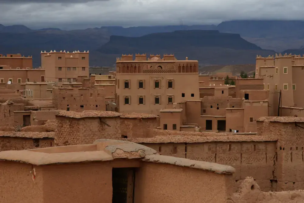
Saghro is a range of rock towers, plateaus and gorges east of Ouarzazate. Its highest point is Amalou n'Mansour (2,712 m), south-east of Iknioun. The classic north–south crossing does not go over it: it tops out at the Kouaouch pass, 2,592 m. Other landmarks are the pass of Tizi n'Tazazert (2,283 m), the plateau around Igli and the twin rock spires of Bab n'Ali. Nkob, at the southern foot of the range, is at 1,045 m.
Trek descriptions give three main lines. The north–south crossing from Tagdilt to Nkob is the one most described, in 5–7 days. A loop from Nkob covers much of the same ground without a one-way transfer. The eastern line goes over Amalou n'Mansour to Iknioun and takes 5 days or more. Trekking here is little developed: villages are few, and camping is the only option across much of the range. Altitude is modest everywhere.
| Route | Days | Scenery | Crowds | Acclimatisation |
|---|---|---|---|---|
| Tagdilt to Nkob, north to south itinerary belowThe line most often described: from Tagdilt, near Boumalne Dades, over the Kouaouch pass (2,592 m) to Igli, down past Bab n'Ali and through gorges and palm villages to Nkob. Five walking days, plus a drive at each end if you start and finish in Marrakech. It can be walked in reverse. | 5–7 | Excellent | Low | Very good |
| Nkob loopA circular route of about 88.5 km from Nkob: up to Bab n'Ali, over the Kouaouch pass, through the oases and back to Nkob by Handour. You start and finish in the same place, so there is no one-way transfer, and Nkob is where guides and mules are easy to find. | 4–7 | Excellent | Low | Very good |
| Eastern line over Amalou n'Mansour to IkniounThe way to the range's highest point, Amalou n'Mansour (2,712 m). From Nkob or the southern valleys past Bou Gafer to Iknioun, the road head for this line, in 5 days or more; peaks along the way are over 2,300 m. Longer treks join this line to the western crossing: one club group walked about 203 km in 11 days of walking and finished at Iknioun (1,925 m). | 5–11 | Excellent | Low | Very good |
5-day Tagdilt to Nkob, north to south itinerary at a glance
The itinerary below is the north–south crossing in five walking days, as in a typical operator itinerary. Operators usually add a drive from Marrakech over the Tizi n'Tichka pass to Tagdilt before day 1, and a drive back from Nkob after day 5. Day 1 climbs into a steep side valley, about five hours. Day 2 is shorter but highest: over the Kouaouch pass (2,592 m), with views north to the High Atlas, and down to Igli. The Tassigdelt Tamajgalt plateau on this stretch has rock formations nicknamed the Camel's Head and the Elephant. Day 3 is the longest, about 17.5 km from Igli to Bab n'Ali, between about 1,852 m and 1,373 m. Bab n'Ali is a pair of volcanic spires; a local legend says a boy named Ali was turned to stone here. Day 4 follows a gorge past Assaka to the Taoudachte river, through villages with palms and almond trees. Day 5 follows the river down to Nkob.
Nights are in camps with mule-carried tents, with gîtes or village houses at Tagdilt, Igli and near Nkob on some itineraries. Water comes from wells and occasional springs and should be treated.
- Day 1 Tagdilt Amda n'Oughyoul
- Day 2 Amda n'Oughyoul Igli via Kouaouch pass 2,592 m
- Day 3 Igli Bab n'Ali
- Day 4 Bab n'Ali Ighazoune n'Oumlas (Taoudachte river)
- Day 5 Ighazoune n'Oumlas Nkob camp at 1,045 m
What it really costs
Treks usually run as a package with a guide, a muleteer, a cook and mules, or you can arrange the same team in Nkob or Boumalne Dades. Package prices depend on group size and days, so compare them on the booking sites. The figures below are approximate, and none is official.
Insurance that covers Jbel Saghro traverse
Choose a policy that covers trekking in remote mountains up to at least 2,600 m, or 2,712 m for the eastern line, including search, rescue and evacuation. Saghro is sparsely populated, there are no medical facilities on the route, and rescue in Morocco is by the Gendarmerie, Civil Protection and the army.
In an emergency, call 15 for ambulance and fire, 19 for police in towns, or 177 for the Gendarmerie Royale in the countryside and mountains. The US State Department rates Morocco Level 2, exercise increased caution (reported current in September 2026). The UK government's Morocco page includes advice on hiking: read it before you go.
Staying connected in Morocco
eSIMs work in Morocco, and there are tourist SIM stands at the airports. Maroc Telecom is reported to have the strongest rural coverage. On Saghro itself, don't count on a signal: a 2011 trip report found coverage unreliable in this remote range.
Download offline maps before you start, since the ground is often pathless, carry a power bank and leave your plan with someone at home.
Getting there and where to stay
Ouarzazate airport (OZZ) is the closest, 2 km from town; Marrakech (RAK) is the usual international arrival, about five hours from Ouarzazate by bus. Nkob, at the southern end, is about 140 km east of Ouarzazate on the N9; Boumalne Dades, near Tagdilt at the northern end, is on the N10. Check current schedules before you travel.
Getting there by air
Marrakech to Ouarzazate
Ouarzazate to Nkob
Ouarzazate to Boumalne Dades
Gear: rent or buy
Nothing technical, but cold nights, strong sun and rough rock. In Ouarzazate, at 1,151 m, January nights average about 2 °C and have dropped to −7 °C; camps higher in the range will be colder. Winter days are clear and pleasant. Water is scarce, so carry it between sources and treat it.
- Sleeping bag rated below freezing for winter nightsRent or buy
- Broken-in boots with ankle support for rocky, often pathless groundBuy
- Water bottles for the day (one operator asks for 1–1.5 litres) and purification tablets or a filterBuy
- Down or synthetic jacket, hat and gloves for evenings in campRent or buy
- Sun hat, sunglasses and high-factor sunscreenBuy
- Trekking poles for loose descents into the gorgesRent or buy
- Headlamp, for long winter nightsBuy
- Phone with offline maps, plus a power bankBuy
Add a few days in Morocco
Nkob sits on the road between Ouarzazate and the desert, so a few extra days fit easily before or after the trek.
The kasbahs of Nkob
On to Merzouga and the dunes
Frequently asked questions
How hard is the Jbel Saghro traverse?
Moderate. Operator itineraries walk about four to six hours a day on rough, rocky and often pathless ground, with one climb to about 2,592 m. There are no technical sections and altitude is modest. You do need to be comfortable on uneven ground for several days in a row, and to manage cold nights and limited water.
What is the highest point, and does the classic trek reach it?
2,712 m, at Amalou n'Mansour, and no. The classic Tagdilt to Nkob crossing tops out on the shoulder of Jbel Kouaouch at 2,592 m. Amalou n'Mansour is on the eastern line to Iknioun, which takes 5 days or more.
Do I need a guide?
Not legally required as far as we could find, but almost every trek runs with a licensed guide and a muleteer; check at booking. Official mountain guides hold an agrément, and Saghro is one of the areas it covers: ask to see the guide's official card. Route-finding on pathless ground and finding water are good reasons to walk with a local team. Guides and mules are easy to find in Nkob.
What about food, dietary needs and faith on the trek?
Meals are Moroccan home cooking (tagine, couscous, harira, bread, mint tea) made by your crew or the gîte. If you eat halal, expect it, but ask your guide or operator how meat is sourced. If you are vegetarian or vegan, or have an allergy or another dietary need, tell your operator when you book so the cook can plan for it. Kosher food is not something to expect on the trek; bring your own if you need it.
Morocco is a Muslim-majority country, so expect village mosques and the call to prayer, though many camps on Saghro are far from any village. If you pray, ask your guide to plan prayer stops, a clean, quiet place to pray and the qibla direction at camps. Water is scarce and carried by mule, so agree how much is set aside for wudu, or plan for tayammum. For any religious practice that needs time or space on the trek, agree it with your guide or operator before you start. Ramadan 2027 is expected from about 8 February to 9 March, in the middle of the season: ask your operator how the team handles fasting days and meal times.
Which languages do guides speak?
Guides and muleteers speak Darija and Tamazight. If you want a guide who also speaks another language, such as English, French or Spanish, ask for one when you book.
Should I tip the guide and muleteers?
We found no published rate for Saghro. Ask your operator what is usual for your group size and number of days, and agree it before you start.
Which visa do I need?
It depends on your passport. Check whether it is on Morocco's visa-exempt list; passports of the UAE, Saudi Arabia, Qatar, Kuwait, Bahrain and Oman, for example, are on it. Check the length of stay with the Moroccan embassy. If your passport is not on the list, you may need the e-visa from the official portal, acces-maroc.ma (770 MAD standard, 1,100 MAD express, up to 30 days). UAE residents with an Emirates ID and at least 180 days' residency qualify. As of November 2026, you may take at most 2,000 MAD in banknotes out of Morocco. Take cash from ATMs in Marrakech or Ouarzazate before the mountains.
When should I go?
October to April. Saghro is a winter trek: days are clear and pleasant while the High Atlas to the north may be under snow. Winter nights are very cold. From May to September the range is too hot, with summer desert highs over 40 °C.
Is there water on the trail?
Very little. Water comes from wells, occasional springs and rock pools, and must be treated; some sections have no reliable source at all. Groups rely on mules to carry water and supplies. Carry enough for the day, with tablets or a filter, and don't drink from pools without treating the water.
How cold does it get at night?
It can drop below freezing on winter nights. Ouarzazate, at 1,151 m, averages about 2 °C at night in January and has recorded −7 °C; camps in the range are higher and colder. In April 2016 a club group found three-season sleeping bags enough.
How do I get to Nkob by public transport?
Take the bus from Marrakech to Ouarzazate (about five hours, about 80–95 MAD). Then take a grand taxi to Nkob (about 60 MAD, around 08:00), or a bus to Tansikht and a shared taxi from there. Nkob is about 140 km east of Ouarzazate. Fares are approximate and may have changed.
Who are the Aït Atta nomads?
Semi-nomadic Amazigh families who winter in Saghro and move to the Aït Bouguemez area in summer. Their numbers are falling as families settle. Trekkers may meet them on the way; ask your guide before visiting or taking photographs.
Sources and last check
- Wikipedia: Jbel Saghro, high point, summits, climate, Aït Atta, roads (checked 6 Nov 2026)
- Jbel Amalou n'Mansour, 2,712 m, second source (checked 6 Nov 2026)
- Walkopedia: Jebel Sarhro, routes, season, Nkob as base, camping and water (checked 6 Nov 2026)
- Yorkshire Ramblers' Club Journal: April 2016 Jebel Sarhro trek, GPS altitudes, weather, water (checked 6 Nov 2026)
- Hiking Project: Jebel Saghro trek, distance, days, season, Kouaouch pass (checked 6 Nov 2026)
- Hiking Project: Igli to Bab n'Ali segment (checked 6 Nov 2026)
- Lonely Planet: hikes in Morocco, Saghro days, distance, grade (checked 6 Nov 2026)
- TrekAtlas: itinerary Tagdilt to Nkob, stages and walking times (operator, checklist only) (checked 6 Nov 2026)
- Stanford trip report, April 2014: Tassigdelt Tamajgalt rock formations, rock pools (checked 6 Nov 2026)
- Wikipedia: N'Kob, altitude and distances (checked 6 Nov 2026)
- Wikipedia: Id Bab N Ali, the rock spires and legend (checked 6 Nov 2026)
- Wikipedia: Ouarzazate, climate normals 1991–2020 (checked 6 Nov 2026)
- Wikivoyage (2025 snapshot): Nkob, transport, lodging and a trek price (checked 6 Nov 2026)
- Morocco Travel Blog: Nkob and the Aït Atta (checked 6 Nov 2026)
- Busbud: CTM Ouarzazate to Boumalne Dades (checked 6 Nov 2026)
- Frommer's: Ouarzazate, buses and airport (checked 6 Nov 2026)
- Moroccan mountain guide agrément, conditions and areas (checked 6 Nov 2026)
- Bladi: Morocco's visa-exempt countries (checked 6 Nov 2026)
- Gulf News: Morocco e-visa for UAE residents (checked 6 Nov 2026)
- Bladi: dirham banknote export limit, October 2026 (checked 6 Nov 2026)
- AACO: Royal Air Maroc resumes Doha and Dubai, July 2026 (checked 6 Nov 2026)
- FlightConnections: nonstop flights from Casablanca (checked 6 Nov 2026)
- The National: Ramadan 2027 expected dates (checked 6 Nov 2026)
- Jbel Sahro practicalities, December 2011 trip report: phone coverage and medical help in remote areas (checked 6 Nov 2026)
- MarocMama: mobile coverage and eSIMs in Morocco, July 2026 (checked 6 Nov 2026)
- Emergency numbers 15, 19, 177 (checked 6 Nov 2026)
- US State Department: Morocco travel advisory (checked 6 Nov 2026)
- UK FCDO: Morocco safety and security, including hiking (checked 6 Nov 2026)