
Jbel Sirwa (Siroua) trek: a 6- to 7-day loop from Taliouine over a 3,304 m volcanic summit
Jbel Sirwa, also written Siroua, is an old volcano of 3,304 m where the High Atlas meets the Anti-Atlas. The usual trek is a loop of 6–7 days from Taliouine (about 1,080 m), a small town known for its saffron, through terraced villages and river valleys to summer pastures at about 2,650 m, then over the twin-topped summit and down through the Tislit gorge. Most nights are in tents, with a cook team and mules carrying the bags. The summit ridge is steep and needs some scrambling, but no ropes or climbing gear. Here is what to expect, as of November 2026.
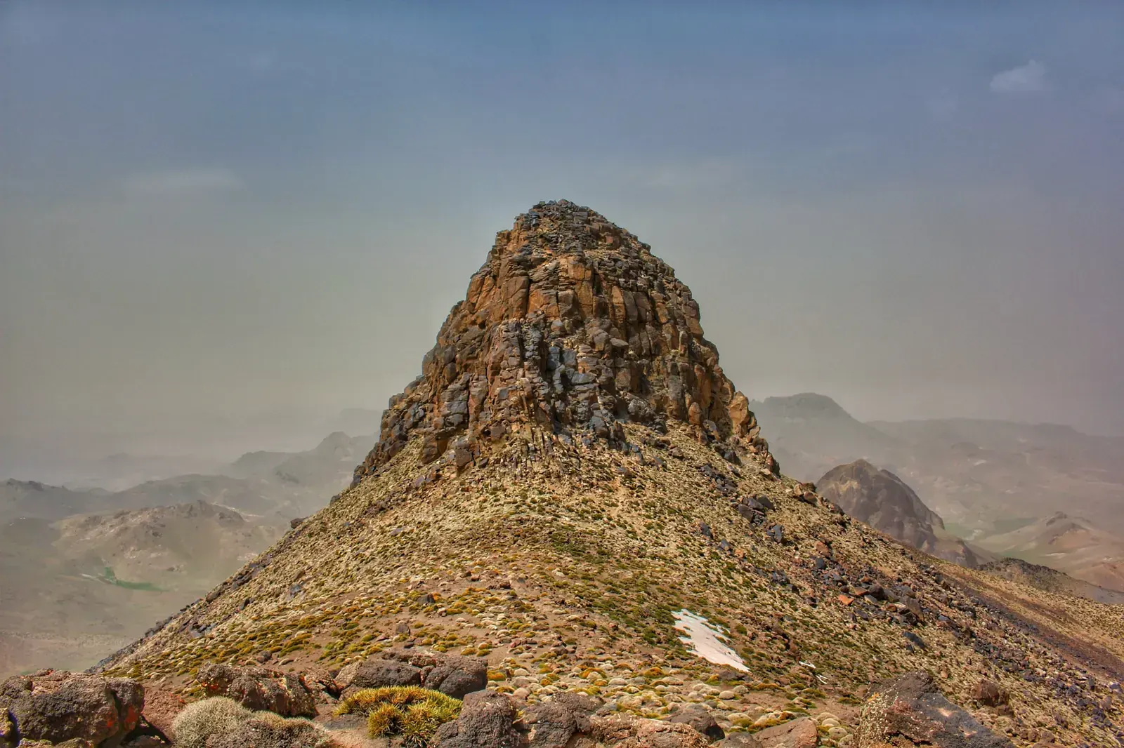
- High point
- 3,304 m · Jbel Sirwa summit
- Duration
- 6–7 days
- Best months
- Apr–May, Oct–Nov
- Difficulty
- Moderate, non-technical
- Guide
- Not required
For guidance only. Check details with your operator and the official sources listed at the end before you book.
Where to book and compare Jbel Sirwa (Siroua) trek trips
Booking sites · affiliate linksEach site lists trips from several operators. Compare dates, group sizes, what is included and reviews there; we don't rank operators.
We earn a commission if you book through these links, at no extra cost to you. Prices and availability are on each site.
On this page
Which route should you choose?
Jbel Sirwa is an extinct volcano at the junction of the High Atlas and the Anti-Atlas. Two approaches are used. The southern loop, the classic route, starts and ends near Taliouine (about 1,080 m), on the N10 road between Ouarzazate and Taroudant. The northern approach starts at Tamlakhout, reached over the Tizi n'Tichka pass from Marrakech.
Both take about 6 walking days and reach the summit on the fourth day. The summit is 3,304 m in Britannica, OpenStreetMap and Wikidata; some sources give 3,305 m. Every itinerary we found runs with a local guide, a cook and mules. Most nights are in tents, with a gîte or a family house at the start or the end.
| Route | Days | Scenery | Crowds | Acclimatisation |
|---|---|---|---|---|
| Southern loop from Taliouine itinerary belowThe classic route: Taliouine to Akhfamane, Ti n'Iddr, Tegragra, the summit, Tizgui and the Tislit gorge, finishing at Tinfat or Souk Larba. Nights climb slowly, from about 1,250 m to 2,650 m before the summit. Some groups treat the summit as optional and walk round it. | 6–7 | Excellent | Low | Very good |
| Northern approach via TamlakhoutStarts on the Marrakech side: a drive over the Tizi n'Tichka pass to Tamlakhout (also Tamlakout), about 1,600 m to 1,700 m depending on the source, with a gîte for the first night. Camps at about 2,000 m to 2,400 m follow, and the summit comes on the fourth walking day. Closer to Marrakech by road. | 6 | Excellent | Low | Good |
7-day Southern loop from Taliouine itinerary at a glance
The itinerary below is the southern loop in seven days, the last day being the drive back. The mules are loaded at the start. Day 1 follows the Oued Zagmouzen past small villages to Akhfamane, about 4 to 5 hours. Day 2, about 6 hours, crosses two river valleys and terraced villages via Mazwad to Ti n'Iddr, which has a kasbah, a mosque and an agadir, a collective granary. Day 3 is the big climb: about 1,000 m of ascent in 6 to 7 hours. It passes Atougha, the last village, then zigzags up to the summer pastures of Tegragra near a spring.
Day 4 starts early: 2 to 3 hours up a steep ridge with some scrambling to the twin-topped summit. Then about 4 hours down to Tizgui, a village with a fortified granary. Day 5, about 5 hours, descends through villages to the Tislit gorge. Day 6 crosses terraced fields to Tinfat, about 20 km in 6 to 7 hours. Day 7 is the road back to Taliouine and on to your airport.
- Day 1 Taliouine Akhfamane night at 1,250 m
- Day 2 Akhfamane Ti n'Iddr
- Day 3 Ti n'Iddr Tegragra pastures night at 2,650 m
- Day 4 Tegragra, over Jbel Sirwa Tizgui summit 3,304 mnight at 2,200 m
- Day 5 Tizgui Tislit gorge
- Day 6 Tislit gorge Tinfat
- Day 7 Tinfat Taliouine (by road)
What it really costs
Most walkers book a package with a guide, cook, mules, tents and food. We found no official or press prices for guides, mules or gîte nights on Sirwa as of November 2026. The rows below say what to agree rather than what to pay.
Insurance that covers Jbel Sirwa (Siroua) trek
Choose a policy that covers trekking up to 3,304 m, with mountain rescue and evacuation by road or helicopter. In Morocco, mountain rescue is carried out by the Gendarmerie, Civil Protection and the army; check that your policy pays for it from a remote valley. The summit day includes a steep, scrambling ridge.
Emergency numbers: 15 for ambulance and fire, 19 for police in towns, 177 for the Gendarmerie Royale in the countryside and mountains. The US State Department has Morocco at Level 2, exercise increased caution; the UK government publishes hiking advice on its Morocco safety page. Read both before you go.
Staying connected in Morocco
eSIMs work in Morocco, and airports have tourist SIM stands. We found no report on mobile coverage on the Sirwa massif, so plan for none between villages and tell someone your route.
Camps have no charging: bring a power bank big enough for the whole trek, and download offline maps before you leave Taliouine.
Getting there and where to stay
Taliouine is the base town, on the N10 between Ouarzazate and Taroudant. The gateway is Ouarzazate (OZZ), whose airport is about 2 km from town; Marrakech (RAK) is the common alternative, and Agadir (AGA) also works, about 4 hours by road via Taroudant. Ask whether your package includes the transfer to the trailhead.
Getting there by air
By road to Taliouine
To the northern trailhead
Gear: rent or buy
Nothing technical, but long days, a steep summit ridge with some scrambling, and camps up to about 2,650 m. Mules carry your bag, so you walk with a daypack; on summit day the mules take another way and you carry your own lunch. One club caps bags at 12 kg in a soft bag, with no hard suitcases.
- Broken-in boots with ankle support for stony paths and the summit scrambleBuy
- Daypack big enough for lunch, water and a warm layer on summit dayBuy
- Water bottles and purification tablets or a filter: you treat your own drinking waterBuy
- Warm jacket and a sleeping bag for camps up to about 2,650 mRent or buy
- Sun hat, sunglasses and high-factor sunscreenBuy
- Trekking poles for the steep descentsRent or buy
- Headlamp for the early summit startBuy
- Power bank for the whole trek: no charging at campBuy
- Soft duffel bag for the mules, not a hard suitcaseBuy
Add a few days in Morocco
Taliouine is Morocco's saffron town, and the road to Agadir passes through Taroudant, so a spare day before or after is easy to fill.
Saffron harvest and festival in Taliouine
The Saffron Route by road
A night in Taroudant
Frequently asked questions
How high is Jbel Sirwa?
3,304 m, the figure in Britannica, OpenStreetMap, Wikidata and the English Wikipedia article. Some sources give 3,305 m. The summit has two tops, reached by a steep ridge, and nights on the southern loop stay at or below about 2,650 m.
How hard is the Jbel Sirwa trek?
Moderate, close to hard on summit day. Days are about 4 to 7 hours, day 3 has about 1,000 m of climbing, and the summit ridge is steep with some scrambling. A French alpine club grades it moderate plus; other descriptions call it moderate and sometimes strenuous, suited to hikers with some experience. No ropes or climbing gear are needed.
Do I need a guide?
Not legally required as far as we could find, but almost every trek runs with a licensed guide and a muleteer; check at booking. Official mountain guides in Morocco hold an agrément, which requires a diploma from a mountain-guide training centre and an exam, and Sirwa is one of the listed areas. Ask to see the guide's official card. Unlike Toubkal, we found no checkpoint rule for Sirwa as of November 2026.
What about food, dietary needs and faith on the trek?
Expect Moroccan home cooking from the cook team: picnic lunches on the trail and hot dinners at camp, typically tagine, couscous, harira, bread and mint tea. If you eat halal, ask your guide or operator how meat is sourced. If you are vegetarian or vegan, or have an allergy or another dietary need, tell your operator when you book so the cook can plan for it. Kosher food is not something to expect on the trek; bring your own if you need it.
Morocco is a Muslim-majority country and the route passes through villages with mosques, Ti n'Iddr among them. If you pray, ask your guide to plan prayer stops, a clean and quiet place to pray and the qibla direction at camp. The early start on summit day falls around Fajr, so plan it together. For any religious practice that needs time or space on the trek, agree it with your guide or operator before you start. Ramadan 2027 is expected from about 8 February to 9 March; ask your operator how the team handles fasting days and meal times.
Which languages do guides speak?
Local guides speak Darija (Moroccan Arabic) and Tamazight. If you want a guide who speaks another language well, such as English, French or Spanish, ask your operator when you book.
Which visa do I need?
It depends on your passport. Check whether it is on Morocco's visa-exempt list; passports of the UAE, Saudi Arabia, Qatar, Kuwait, Bahrain and Oman, for example, are on it. Check the length of stay with the Moroccan embassy. If your passport is not on the list, you may need the e-visa from the official portal, acces-maroc.ma (770 MAD standard, 1,100 MAD express, single entry, up to 30 days); UAE residents with an Emirates ID and at least 180 days' residency qualify for it.
When should I go?
April to May or October to November. Spring and autumn avoid the strong summer sun, and spring is popular while Toubkal is still snowbound. In October and November you can add the saffron harvest in Taliouine. We found no monthly temperature data and no source on winter snow on Sirwa, so check the forecast and ask your operator.
Should I tip the guide, cook and muleteers?
Agree it in advance. We found no published rate for Sirwa; ask your operator what is usual for your group size and the length of the trek, and carry cash in dirhams for it.
Can I combine the trek with the saffron harvest?
Yes, in October and November. Saffron around Taliouine is picked by hand early in the morning in those months, and the saffron festival is usually held in November (20 to 23 November in 2025). No dates were published for 2026 when we checked, so confirm them locally.
Where do I sleep on the trek?
In tents on most nights, with a gîte or a Berber family house on the first or last night. Groups use two-person tents with foam mats and a kitchen and dining tent; we found no mountain refuges on the massif, and there is no charging at camp.
Which airport is closest: Ouarzazate, Marrakech or Agadir?
Ouarzazate (OZZ) for the southern loop, on the N10 road to Taliouine. Agadir (AGA) works via Taroudant, about 4 hours by road. Marrakech (RAK) has more flights and suits the northern approach, about 5 hours by road to the trailhead. Ask whether your package includes transfers.
Was the area affected by the 2023 earthquake?
Taliouine and Sirwa are in Taroudant province, which was badly hit by the 8 September 2023 Al Haouz earthquake. We found no damage report specific to the Sirwa route and no report of a closed trail, as of November 2026. Ask your operator about current conditions in the Sirwa villages.
Sources and last check
- Summit altitude 3,304 m, old stratovolcano (checked 6 Nov 2026)
- Summit altitude 3,304 m, volcanic peak of the Anti-Atlas (checked 6 Nov 2026)
- OpenStreetMap and Wikidata altitude 3,304 m (checked 6 Nov 2026)
- Alternative altitude 3,305 m, prominence (checked 6 Nov 2026)
- Taliouine about 1,080 m on the N10, buses and grand taxis from Ouarzazate and Taroudant, saffron harvest, festival usually in November (checked 6 Nov 2026)
- Southern loop itinerary, night altitudes and walking times (operator, checklist only) (checked 6 Nov 2026)
- Southern loop club trip, April 2024: altitudes, villages, logistics via Agadir (checked 6 Nov 2026)
- Northern approach club trip, October 2025: altitudes, camps, gear, transfer from Marrakech (checked 6 Nov 2026)
- Northern approach, grade and seasons (operator, checklist only) (checked 6 Nov 2026)
- Saffron festival Anmugar Amadal N Zafran (checked 6 Nov 2026)
- Taliouine, Taroudant province, saffron festival (checked 6 Nov 2026)
- Agadir to Taroudant distance, Saffron Route, harvest season (checked 6 Nov 2026)
- Mountain guide agrément and areas including Sirwa (checked 6 Nov 2026)
- US State Department Morocco travel advisory (checked 6 Nov 2026)
- UK FCDO Morocco safety and hiking advice (checked 6 Nov 2026)
- GCC passports on Morocco's visa-exempt list (checked 6 Nov 2026)
- Morocco e-visa fees and UAE-resident eligibility, March 2024 (checked 6 Nov 2026)
- Dirham banknote export limit, October 2026 (checked 6 Nov 2026)
- Royal Air Maroc Doha and Dubai flights from July 2026 (checked 6 Nov 2026)
- Dubai to Casablanca nonstop flights (checked 6 Nov 2026)
- Nonstop routes from Casablanca to the Gulf (checked 6 Nov 2026)
- Ouarzazate airport distance, CTM buses from Marrakech (checked 6 Nov 2026)
- Ramadan 2027 expected dates (checked 6 Nov 2026)
- Drive from Agadir to the Sirwa area about 4 hours, via the N10 and Taliouine (checked 6 Nov 2026)
- Saffron festival 2025 edition, 20 to 23 November (checked 6 Nov 2026)
- 2023 earthquake provisional toll by province, Taroudant included (checked 6 Nov 2026)
- eSIMs and tourist SIMs in Morocco (checked 6 Nov 2026)
- Emergency numbers 15, 19, 177